
Wow. Just in time for Paris.
My guesswork now looks a little lame as the Nasa October land-ocean temperature anomaly shoots upwards to a new record of 1.04 degrees Celsius.

Monthly anomalies for selected hot years since 1998. My guesswork forecasts are shown in dashed and dotted lines. Data from NASA.
A clear all-time temperature record for 2015 is now assured, because November and December anomalies would now have to be less than 0.34 degrees, a level not seen for those months since 2000, for 2014 to retain the warmest year record.
My original anomaly forecast for the year was 0.82 degrees C , which is unchanged below, but is clearly now conservative and is shown by the red square. The red cross (0.86 degrees C) is a projection based on November and December averaging the same anomaly as October.
As Michael Caine put it:
Update: Here is Sou’s year-to-date graph.

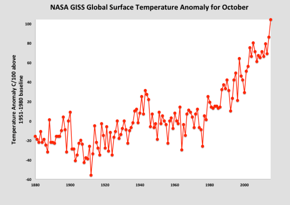
Greg Laden has more graphs including this one, showing how this October compares with Octobers from previous years:
And here is a graph from Stefan Rahmstorf showing all of the monthly anomalies since 1880

